Community Mapping Lab
  • Home
  • About
    • Our mission
    • Who we are
    • Partners
    • Contact
  • Activities
    • Community GIS (Geog4/6385)
    • CURO
    • Mapping with QGIS
    • CommGeog19
  • Projects
    • Athens Black history and places >
      • ACC Black-owned businesses
      • Black history sites in Athens
      • Brooklyn Cemetery
      • Linnentown
      • Hot Corner
      • Reese Street
    • Athens Wellbeing Project
    • Athens 1958 City Directory
    • Athens bike routes
    • Atlanta Community Food Bank
    • Evictions in Athens
    • Digitizing Athens Sanborn Maps
    • GA Hunger study: Proximity map
    • Georgia Initiative for Community Housing
    • Historic Cobbham Neighborhood
    • R-51 and urban renewal in Athens
    • Sparrow's Nest
  • Blog
  • Resources
  • Calendar
Access the current dataset | Date last updated: 5/22/24

1958 City Directory

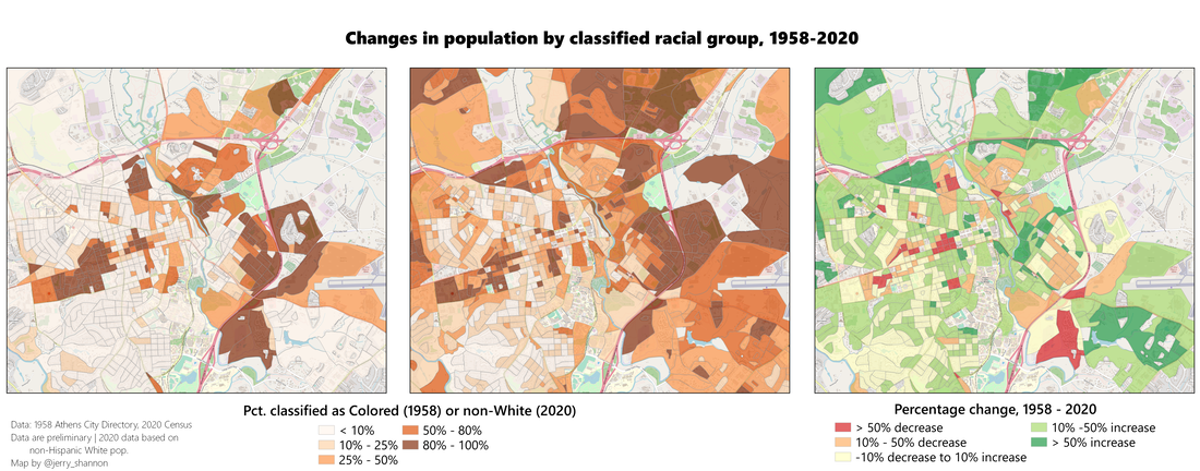
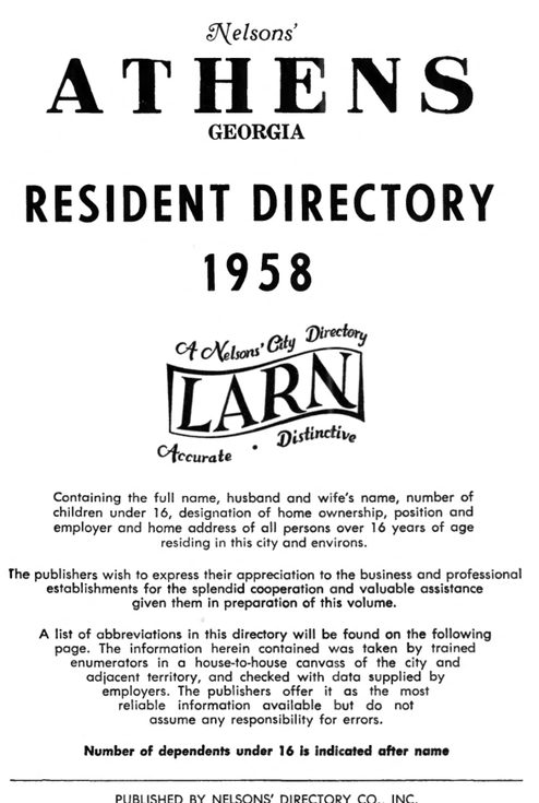
The 1958 City Directory of Athens provided information on not just residents' names and addresses, but additional variables related to employment, housing status, and race. The CML is digitizing this directory to create a public database of the Athens at this time which can be used to map the landscape of employment and residential segregation, as well as the footprint of the University of Georgia within the city. This has included scanning the directory itself and also creating a period street network that will allow those records to be geocoded.

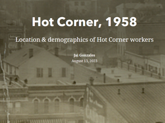
Currently, the directory has been used to inform maps of Hot Corner in Athens, and we are currently creating a set of storymaps for the Reese Street Historic District.
For those who are contributing to this effort, links to resources are found below:
  • Download a PDF of the directory
  • Slides used for the introduction to our project (see video below)
Picture
Picture
Introduction to the project and data cleaning
Link to the slides
Some preliminary research done with this data:
Picture
Picture
Above: Two recent projects by CURO students. Link with more information here.
Picture

About us

Courses

Projects

  • Home
  • About
    • Our mission
    • Who we are
    • Partners
    • Contact
  • Activities
    • Community GIS (Geog4/6385)
    • CURO
    • Mapping with QGIS
    • CommGeog19
  • Projects
    • Athens Black history and places >
      • ACC Black-owned businesses
      • Black history sites in Athens
      • Brooklyn Cemetery
      • Linnentown
      • Hot Corner
      • Reese Street
    • Athens Wellbeing Project
    • Athens 1958 City Directory
    • Athens bike routes
    • Atlanta Community Food Bank
    • Evictions in Athens
    • Digitizing Athens Sanborn Maps
    • GA Hunger study: Proximity map
    • Georgia Initiative for Community Housing
    • Historic Cobbham Neighborhood
    • R-51 and urban renewal in Athens
    • Sparrow's Nest
  • Blog
  • Resources
  • Calendar