Community Mapping Lab
  • Home
  • About
    • Our mission
    • Who we are
    • Partners
    • Contact
  • Activities
    • Community GIS (Geog4/6385)
    • CURO
    • Mapping with QGIS
    • CommGeog19
  • Projects
    • Athens Black history and places >
      • ACC Black-owned businesses
      • Black history sites in Athens
      • Brooklyn Cemetery
      • Linnentown
      • Hot Corner
      • Reese Street
    • Athens Wellbeing Project
    • Athens 1958 City Directory
    • Athens bike routes
    • Atlanta Community Food Bank
    • Evictions in Athens
    • Digitizing Athens Sanborn Maps
    • GA Hunger study: Proximity map
    • Georgia Initiative for Community Housing
    • Historic Cobbham Neighborhood
    • R-51 and urban renewal in Athens
    • Sparrow's Nest
  • Blog
  • Resources
  • Calendar

Brooklyn Cemetery

Brooklyn Cemetery  was one of the first cemeteries in Athens for the African American Community, created in 1882 and used consistently through much of the 20th century. In recent years, the cemetery's board of trustees has worked with a broad range of volunteer groups to renovate and publicize this space. That has included work to catalog all who might be buried in the cemetery, a task made difficult by a lack of official records and broken or missing grave markers.

Community GIS: Spring 2025
Students in the Spring 2025 Community GIS class have focused on documenting the families buried in Brooklyn Cemetery. Drawing on archival documents (census records, city directories, newspaper records) as well as existing genealogical research, students have developed histories for several families located within the cemetery. These include short biographies, maps of homes and workplaces, and other notable documents. They also have been in conversation with Ms. Linda Davis and others connected to the cemetery for their memories and perspectives.

Click on the image below to access the storymaps created by these students. You can also provide feedback on these projects on this form.
Picture
Community GIS: Spring 2023
Students in the Spring 2023 Community GIS class worked with the chair of the Brooklyn Cemetery board, Linda Davis, and other local residents to collect the multiple datasets related to the cemetery and those who are buried there. They digitized these records and checked them for accuracy using GPS devices. Lastly, they created both print and online maps of the cemetery space, shown on this page.
Picture
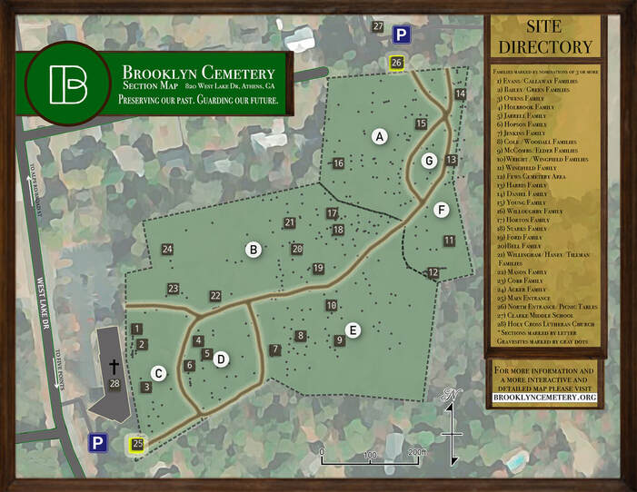
Cemetery map created by Tim Naff, Community GIS student
Picture
Picture
Searchable web map created by Community GIS students:

About us

Courses

Projects

  • Home
  • About
    • Our mission
    • Who we are
    • Partners
    • Contact
  • Activities
    • Community GIS (Geog4/6385)
    • CURO
    • Mapping with QGIS
    • CommGeog19
  • Projects
    • Athens Black history and places >
      • ACC Black-owned businesses
      • Black history sites in Athens
      • Brooklyn Cemetery
      • Linnentown
      • Hot Corner
      • Reese Street
    • Athens Wellbeing Project
    • Athens 1958 City Directory
    • Athens bike routes
    • Atlanta Community Food Bank
    • Evictions in Athens
    • Digitizing Athens Sanborn Maps
    • GA Hunger study: Proximity map
    • Georgia Initiative for Community Housing
    • Historic Cobbham Neighborhood
    • R-51 and urban renewal in Athens
    • Sparrow's Nest
  • Blog
  • Resources
  • Calendar